The summer of 1995 was no ordinary summer in Chicago. That July, the Midwest experienced a five-day streak of extreme heat, and Chicago was impacted by one of its worst heatwave events resulting in over 700 heat-related deaths.
Though this was a turning point for the city in many ways, it was the spark that led many urban planners and city officials to better understand Chicago’s heat vulnerabilities and identify innovative mitigation approaches to protect the city during future heat events.

Since then, Chicago has become a global leader in heat island reduction measures, including landscape ordinances, updated energy codes, and city-wide green roof initiatives. With the dramatic increase in cloud computing-based services and data analytics, Chicago is exploring ways to capitalize on smart city capabilities to further protect residents from urban heat impacts.
To address this need, NASA and Microsoft met with the City of Chicago, Esri, City Tech Collaborative, and D3i Systems to create a new tool to incorporate advanced environmental data into urban design and infrastructure planning. These technical partners are also collaborating with the ultimate goal of helping cities globally to improve their ability to deal with shocks and long-term stressors associated with extreme heat events. The tool’s enhanced mapping and analytics capability will allow stakeholders to zero in on past interventions such as tree planting and the creation of green spaces and understand their impacts on the surrounding climate over time.
Through cutting-edge analytical power provided by Microsoft’s Azure Cloud and mapping functionality provided by Esri’s ArcGIS, NASA environmental data will be incorporated into a visualization dashboard to provide deep insights to urban planners and government officials evaluating the need for and impact of urban green spaces and other mitigation measures used to manage urban hotspots. These same planners and officials will also be able to quantify the heat reduction outcomes from previous interventions, transforming how the city plans and executes critical emergency response services. The team is also investigating the potential benefits of using data collected via Chicago’s Array of Things initiative— an urban measurement project comprised of hundreds of “nodes” installed around Chicago to collect real-time data on the city’s environment, infrastructure, and activity.
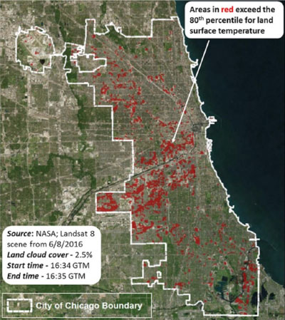
Advanced technologies such as cloud-based data storage, sophisticated analytics, Internet of Things networked in-situ sensors, and Earth observations can be integrated to provide the insight and scale necessary to increase urban resilience and improve heat-related management decisions. The tool will be scalable to other applications and other cities, with the potential to better inform how cities plan and implement future green spaces, cooling shelters, utility-sponsored programs for low-income customers, public health interventions, and weather-related emergency response, ensuring that resources get to the communities and populations that need them most.
Through integrating public and private sector efforts, this project is harnessing the unique capabilities and interests of all parties to achieve together what no single group could alone.