Oil spills have detrimental impacts on ecosystems and economies. Spills can span many square miles dumping thousands of gallons of oil into the ocean which results in scientists across multiple countries working together for solutions. In 2022 and 2023, NOAA's Emergency Response Division supported spill mitigation in Peru and the Philippines using satellite observations of the Earth. NOAA’s Satellite Analysis utilized high resolution optical and Synthetic-Aperture Radar (SAR)-based imagery to provide forecasts and analysis on spill locations, helping to make these two Pacific cleanup efforts more efficient.
In 2022, north of Lima, Peru, a crude oil tanker, Mare Doricum, experienced a spill while unloading contents into underwater pipes at the La Pampilla Refinery. Approximately 500,000 gallons (1,890,000 liters) escaped into the ocean. This spill impacted 24 beaches, five natural reserve areas, and roughly 10,000 people who rely on the region's fisheries and tourism. Peru declared an environmental emergency, labeling it the worst ecological disaster in the country's history. Two NOAA scientists provided on-scene response efforts. In collaboration with the U.S. Coast Guard, the two entities worked together to provide guidance on oil containment and cleanup techniques while also assessing the environmental damage.
In 2023, off the coast of Oriental Mindoro in the Philippines, the tanker Princess Empress sank during rough seas. After it fell 1,200 feet to the ocean floor, it leaked over 230,000 gallons (870,000 liters) of industrial oil into the marine environment. The spill spread over 75 square miles (194 square kilometers), affecting seven Marine Protected Areas and two square miles of mangroves. The spill also reached one of the most biodiverse areas in the nation, the Verde Islands. This catastrophe also impacted dozens of fishing communities and nearly 21,000 individuals who depend on the sea for their livelihoods.
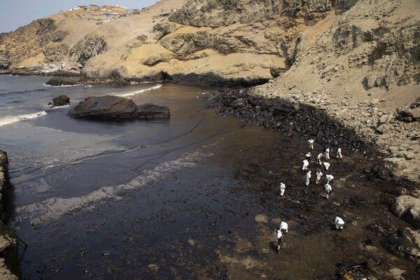
Throughout these crises, NOAA's Satellite Analysis Branch played a crucial role by acquiring and analyzing high-resolution optical and SAR satellite images to provide detailed information about the spills. Optical imagery allowed them to distinguish oil from vegetation and other false positives, however it depended on daylight and clear weather conditions. In contrast, SAR imagery could detect oil day or night and penetrate through clouds but struggled to differentiate oil from other substances. To confirm potential oil sightings, they consulted various additional data sources.
NOAA summarizes their analyses and images in publicly accessible Marine Pollution Surveillance Reports (MPSRs). For international events, these reports are made available on The International Charter: Space and Major Disasters' public website. In these two recent Pacific Ocean cases, these reports were valuable resources for response authorities, such as Peru's space agency, CONIDA. The combination of satellite imagery, analysis, and oil spill modeling enabled authorities to focus their cleanup efforts and interventions.